Maps from William Chrisant & Sons' Florida Book Shop, ABAA, ILAB, FABA
Novidades

Mais fotos
Maps to Accompany the Official Records of the Union and Confederate Armies. Part II.
por United States War Department
- Condição
- Usado - Very Good
- Edição
- First Edition
- Published
- 1891
- Quantidade Disponível
- 1
- Livreiro
-
Fort Lauderdale, Florida, USA
- Preço do item
-
€ 1.229,80
Mostrar detalhes
Descrição:
Full black cloth with gilt title to front. A total of 58 double-page maps with pagination beginning at plate LXI and ending with plate CXIX. Small, faint "Library of Catholic Club" stamp to front fly. Plate LXI has a repaired tear as well as a loss to the bottom left corner (not affecting map). Wear to board fore edges (see… Ler mais sobre este item Preço do item
€ 1.229,80

Mais fotos
La Flotte de Bonaparte sur les côtes d'Egypte.
por Georges Douin
- Condição
- Usado
- Published
- 1922
- Quantidade Disponível
- 1
- Livreiro
-
Fort Lauderdale, Florida, USA
- Preço do item
-
€ 454,08
Mostrar detalhes
Descrição:
Mémoires de la Société Royale de Géographie d'Egypte. Cream linen-covered boards; morocco labels to spine. vii, 149, [1], viii plates. Eight folding maps, six of which are colored. Small loss to cartouche of plate four & Tables des Matieres (nether affecting text). Foxing & thumbing to covers; losses to fore-edge (see images). 10 x 13.9 inches Preço do item
€ 454,08

Mais fotos
Atlas geographique, statistique, historique et chronologique des deux Ameriques
por Jean Alexandre Buchon
- Condição
- Usado - Very Good
- Published
- 1825
- Quantidade Disponível
- 1
- Livreiro
-
Fort Lauderdale, Florida, USA
- Preço do item
-
€ 6.243,60
Mostrar detalhes
Descrição:
Patterned cloth covered boards with gilt particulars to spine. 51 double-page hand-colored maps, 8 letterpress tables, including the American and Columbian Constitutions, and 2 plates, all mounted on guards. Text in French. Two old French stamps on title; no additional markings. This is the French edition of Carey and Lea's Complete historical, chronological, and geographical American Atlas. A remarkably… Ler mais sobre este item Preço do item
€ 6.243,60
![The Adirondack Mountains and Summer Paradise [Two Titles in One]](https://d3525k1ryd2155.cloudfront.net/h/954/846/1477846954.0.m.jpg)
Mais fotos
The Adirondack Mountains and Summer Paradise [Two Titles in One]
- Condição
- Usado - Very Good
- Edição
- First Edition
- Published
- 1903
- Quantidade Disponível
- 1
- Livreiro
-
Fort Lauderdale, Florida, USA
- Preço do item
-
€ 567,60
Mostrar detalhes
Descrição:
Attractive half burgundy fine grain morocco with marbled boards and gilt title to spine. Five raised bands and gilt particulars to partitions. Gilt top edge. Matching marbled endpapers. Two linen backed fold-out maps, one of which takes up significant space in the book and is dated 1899 (see image). The Adirondack Mountains Pp. 84; A Summer Paradise Pp. 267. Numerous… Ler mais sobre este item Preço do item
€ 567,60

Mais fotos
The History of the Decline and Fall of the Roman Empire (6 Volumes - Complete)
por Edward Gibbon
- Condição
- Usado - Very Good+
- Published
- 1781-1788
- Quantidade Disponível
- 1
- Livreiro
-
Fort Lauderdale, Florida, USA
- Preço do item
-
€ 5.676,00
Mostrar detalhes
Descrição:
Professionally rebound in half calf over marbled boards with debossed rule to boards; 6 raised bands, gilt particulars, debossed decoration, and burgundy morocco label to spines. Volumes 1-3 are from 1781 and volumes 4-6 are from 1788. Vol 1 Fourth edition; Vol. 2 Second edition; Vol. 3 Second edition; Vol. 4-6 edition not stated. No previous owners' names or other… Ler mais sobre este item Preço do item
€ 5.676,00

Mais fotos
The Life of Napoleon Bonaparte, Emperor of France. From his birth in 1769 to the Armistace in 1813. Containing an account of his parents, education, preferment, battles, &c., &c. Interspersed with numerous and interesting anecdotes..
por Anonymous
- Condição
- Usado - Good
- Edição
- Second Revised Edition
- Published
- 1813
- Quantidade Disponível
- 1
- Livreiro
-
Fort Lauderdale, Florida, USA
- Preço do item
-
€ 113,52
Mostrar detalhes
Descrição:
Half red calf over marbled boards with gilt particulars to spine. Top edge gilt; marbled endpapers. Five (5) fold-out maps throughout, one of which has been long ago professionally reinforced with linen backing. No previous owners' names or other markings. Page 23/24 dog eared on bottom corner; closed tears and folds to pages 25-28; moisture mark to top exterior corner… Ler mais sobre este item Preço do item
€ 113,52

Mais fotos
History of the Nineteenth (19th) Army Corps
por Richard B. Irwin
- Condição
- Usado - Very Good+
- Edição
- First Edition
- Published
- 1892
- Quantidade Disponível
- 1
- Livreiro
-
Fort Lauderdale, Florida, USA
- Preço do item
-
€ 189,20
Mostrar detalhes
Descrição:
Blue cloth over boards with gilt particulars to front board and spine. Top edge gilt; deckle edges. 15 maps and battle plans throughout. Remnants of previous owner's bookplate to front pastedown, otherwise no other names or markings. Wear to boards with bumping and slight fraying to head and tail of spine (see images). 6 3/4 x 9 3/4 inches. All… Ler mais sobre este item Preço do item
€ 189,20

Course of the River Mississippi from the Balise to Fort Chatres taken on an Expedition to the Illinois in the latter end of the year, 1765.
por Lieut. John Ross
- Condição
- Usado - Very Good
- Published
- 1775
- Encadernação
- Map
- Quantidade Disponível
- 1
- Livreiro
-
Fort Lauderdale, Florida, USA
- Preço do item
-
€ 4.730,00
Mostrar detalhes
Descrição:
Original hand-coloring in outline. The most detailed map of the Mississippi published in the 18th century. Prime meridian: New Orleans and Ferro. Shows historic points of interest, indigenous villages, evidence of German settlements, quarries, mines, boundaries, fertile land, cane fields, French Forts, etc. Relief shown pictorially. Soundings in Gulf of Mexico and Depths of… Ler mais sobre este item Preço do item
€ 4.730,00

Werelt Caert
por Daniel Stoopendaal
- Condição
- Usado - Very Good
- Published
- c. 1690
- Quantidade Disponível
- 1
- Livreiro
-
Fort Lauderdale, Florida, USA
- Preço do item
-
€ 1.750,10
Mostrar detalhes
Descrição:
Stoopendaal's double hemisphere map surrounded by intricate allegorical representations of the continents and Copernican and Ptolemaic solar systems in fine original color. The Island of California is shown after the Visscher model but with a modified northern coast. Dutch text to verso. ; 18.2 x 11.5 inches; All shipments through USPS insured Priority… Ler mais sobre este item Preço do item
€ 1.750,10

Mais fotos
History of the Indian Tribes of North America, with Biographical Sketches and Anecdotes of the Principal Chiefs. Embellished with One Hundred and Twenty Portraits, from the Indian Gallery in the Department of War, At Washington
por Thomas L. McKenney, James Hall
- Condição
- Usado - Fine
- Edição
- Limited Edition
- Published
- 1978
- Quantidade Disponível
- 1
- Livreiro
-
Fort Lauderdale, Florida, USA
- Preço do item
-
€ 283,80
Mostrar detalhes
Descrição:
Full tan leather with gilt decoration to boards, as well as 5 raised bands and gilt particulars to spine. All edges gilt; purple moire endpapers; silk ribbons present. 120 full color portraits, one for each Native American, throughout. Contains three black and white maps at back of volume 2. Introduction by Dr. Herman J. Viola. Light wear to boards and… Ler mais sobre este item Preço do item
€ 283,80

Mais fotos
Exposition de la Cartographie Belge aux XVI, XVII, et XVIII Siecles, Organisee au Musee Plantin-Moretus a l'ocassion du Cinquantenaire de la Societe Royale de Geographie d'Anvers. Tentoonstelling van de Belgische Kaartmalerskunde.
por Fernand van Ortroy
- Condição
- Usado - Very Good
- Published
- 1926
- Quantidade Disponível
- 1
- Livreiro
-
Fort Lauderdale, Florida, USA
- Preço do item
-
€ 104,06
Mostrar detalhes
Descrição:
An attractive full dark blue polished calf with gilt title and designs to spine. Written in French and Dutch. Gilt borders to covers. Five raised bands. Marbled endpapers. Black and white plates, some of which fold-out. No previous owner's names or other markings. Pp. [lv] 59
7.5 x 10.5 Preço do item
€ 104,06

Mais fotos
Scelta di Lettere Edificanti Scritte dalle missioni straniere preceduta da quadri geografici. Storici, politici, religiosi e letterari de' paesi di missione. Accresciuta di un ragguaglio storico sulle Missioni straniere di nuove lettere edificanti ed altri scelti pezzi. Tomo Quinto (Volume 5): Guiana (Seguito), Peru, Chili, Paraguai
- Condição
- Usado - Very Good
- Published
- 1828
- Quantidade Disponível
- 1
- Livreiro
-
Fort Lauderdale, Florida, USA
- Preço do item
-
€ 227,04
Mostrar detalhes
Descrição:
Quarter brown morocco over marbled boards; 4 raised bands with gilt particulars to spine. 16 hand colored hors texte plates throughout with tissue guards present, as well as folding maps.
General wear to exterior (see image); light foxing throughout. 892 pp. 6 x 8 1/2 inches. Preço do item
€ 227,04

Mais fotos
Geographical Atlases in the Library of Congress
por Philip Lee Phillips, F. R. G. S.
- Condição
- Usado - Fine
- Edição
- Limited Edition
- Quantidade Disponível
- 1
- Livreiro
-
Fort Lauderdale, Florida, USA
- Preço do item
-
€ 260,15
Mostrar detalhes
Descrição:
Nine volume set. Limited edition facsimile of the original 1909 edition. Green cloth with gilt titles on spines. A nice clean set with no previous owner's names or other markings. This set was a multiple bought by us when published and never used. Please expect extra postage.
7.25 x 9 in Preço do item
€ 260,15

The Road from Glocester to Coventrey
por John Ogilby
- Condição
- Usado - Very Good
- Published
- C. 1675
- Quantidade Disponível
- 1
- Livreiro
-
Fort Lauderdale, Florida, USA
- Preço do item
-
€ 288,53
Mostrar detalhes
Descrição:
Hand colored map. 19 1/4 15 1/4 inches. Preço do item
€ 288,53
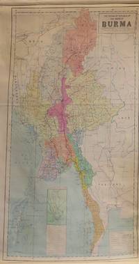
The Socialist Republic of the Union of Burma
- Condição
- Usado
- Quantidade Disponível
- 1
- Livreiro
-
Fort Lauderdale, Florida, USA
- Preço do item
-
€ 416,24
Mostrar detalhes
Descrição:
Linen backed on rollers. Scale 1 : 2,000,000. 25 x 44 inches. Preço do item
€ 416,24
Mais fotos
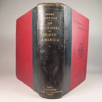
The Discovery of North America, A Critical, Documentary, and Historic Investigation,
por Henry Harrisse
- Condição
- Usado - Very Good
- Edição
- First Edition
- Published
- 1892
- Quantidade Disponível
- 1
- Livreiro
-
Fort Lauderdale, Florida, USA
- Preço do item
-
€ 1.371,70
Mostrar detalhes
Descrição:
Quarter morocco over pictorial maroon cloth board with gilt particulars to spine. Top edge gilt. Limited edition copy No. 91 of 380 issued, this being the English Toned Paper edition. Hors textes plates with tissue guards throughout. Black and white illustrations throughout text as well. Title continued: "to which are added a chronology of one hundred voyages westward, projected, attempted,… Ler mais sobre este item Preço do item
€ 1.371,70
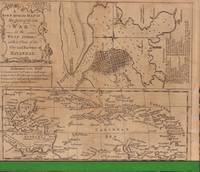
A New & Accurate Map of the Seat of the late War in the West Indies
- Condição
- Usado
- Edição
- First edition
- Published
- 1763
- Quantidade Disponível
- 1
- Livreiro
-
Fort Lauderdale, Florida, USA
- Preço do item
-
€ 236,50
Mostrar detalhes
Descrição:
Derives from The general history of the late war: containing it's rise, progress, and event, in Europe, Asia, Africa, and America by Rev. John Entick et al. Kitchin is most likely the cartographer. Includes 4 indicators of islands ceded by France to G. Britain, Conquered by G. Britain and restored to France, Conquered by G. Britain and restored to Spain,… Ler mais sobre este item Preço do item
€ 236,50

Mais fotos
Map of the City of St. Peter
por A.T. Andreas
- Condição
- Usado - Very Good
- Edição
- First Edition
- Published
- 1874
- Quantidade Disponível
- 1
- Livreiro
-
Fort Lauderdale, Florida, USA
- Preço do item
-
€ 160,82
Mostrar detalhes
Descrição:
Paper. Hand-colored. From the "Illustrated Historical Atlas of the State of Minnesota". 14 x 17 1/2 inches. Four images of residential and commercial buildings to verso, two in Blue Earth Co., and other two in Mankato.
Preço do item
€ 160,82

Mais fotos
Map of Scott County; Map of Shakopee
por A.T. Andreas
- Condição
- Usado - Very Good
- Edição
- First Edition
- Published
- 1874
- Quantidade Disponível
- 1
- Livreiro
-
Fort Lauderdale, Florida, USA
- Preço do item
-
€ 160,82
Mostrar detalhes
Descrição:
Paper. Hand-colored. From the "Illustrated Historical Atlas of the State of Minnesota". 17 1/2 x 14 inches. Map of Shakopee to verso. Light foxing (see image). Two tears to left edge, 1/2 and 1/4 inches. Preço do item
€ 160,82

Mais fotos
Map of Carver County; Map of Carver and Chaska to verso
por A.T. Andreas
- Condição
- Usado - Very Good
- Edição
- First Edition
- Published
- 1874
- Quantidade Disponível
- 1
- Livreiro
-
Fort Lauderdale, Florida, USA
- Preço do item
-
€ 113,52
Mostrar detalhes
Descrição:
Hand-colored maps from the "Illustrated Historical Atlas of the State of Minnesota". 14 x 17 1/2 inches. Map of Carver and Chaska to verso as well as four images of residential and commercial properties to right side. 1/2 and 3/4 inch tears to bottom edge. Minor spotting (see image).
Preço do item
€ 113,52
