Maps from Seth Kaller, Inc.
Novidades

A French Wall Map of the Western Hemisphere
por GASPARD BAILLEUL
- Condição
- Usado - Very Good
- Published
- 1752
- Encadernação
- No binding
- Quantidade Disponível
- 1
- Livreiro
-
White Plains, New York, USA
- Preço do item
-
€ 23.597,50
Mostrar detalhes
Descrição:
Lyon, France, 1752. No binding. Very Good. Map. L'Amerique Divisee en ses Pricipales Parties ou sont distingues les ud de autres les Estats, selon quils appartiennents presentement aux Differents Souverains De L'Europe . . . Par le Sr. Bailleul le jeune Geographe. Jean Louis Daudet, Lyon, France, 1752. Approximately 31 x 40 in., on original wooden rollers. Historical… Ler mais sobre este item Preço do item
€ 23.597,50
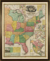
Young's Map of the United States
por S. AUGUSTUS MITCHELL, J. H. YOUNG
- Condição
- Usado - Fine
- Published
- 1831
- Encadernação
- No binding
- Quantidade Disponível
- 1
- Livreiro
-
White Plains, New York, USA
- Preço do item
-
€ 14.158,50
Mostrar detalhes
Descrição:
Philadelphia, 1831. No binding. Fine. Map of the United States. Entered according to Act of Congress in the Clerks Office of the Eastern District of Pennsylvania, October 10th, 1831. [Philadelphia], 1831. Folding map on four sheets joined. Folding into original covers, 8vo (binding size: 9 5/8 x 6 1/2 in.), red half morocco over marbled paper boards, upper… Ler mais sobre este item Preço do item
€ 14.158,50
