Pocket Maps from Donald Heald Rare Books
Novidades

New Map of Boston
por SAMPSON, DAVENPORT & CO.[publisher]
- Condição
- Usado
- Published
- 1875
- Quantidade Disponível
- 1
- Livreiro
-
New York, New York, USA
- Preço do item
-
€ 662,20
Mostrar detalhes
Descrição:
Boston, 1875. Pocket map: 34 1/4 x 28 1/2, hand-colored. Flattened. Cloth cover on back of mat. Expertly restored. This map was "published expressly for the Boston Almanac & Boston Directory."
Shows the city as it grew explosively after the Civil War, including new roads, parks and railroad lines. Preço do item
€ 662,20

Northern Mississippi and Alabama
por [CIVIL WAR] - LINDENKOHL, Adolph
- Condição
- Usado
- Published
- 1864
- Quantidade Disponível
- 1
- Livreiro
-
New York, New York, USA
- Preço do item
-
€ 3.547,50
Mostrar detalhes
Descrição:
[Washington], 1864. Folded map, 24 x 33 inches, in thirty-two segments mounted on linen. Original card covers with printed paper label. Contemporary ownership inscription on label. Some light wear and minor soiling. Detailed field map for the Union Army in Northern Mississippi and Alabama.
A highly detailed map of the northern half of Mississippi and Alabama, showing the… Ler mais sobre este item Preço do item
€ 3.547,50

Mais fotos
Chapman's Sectional Map of Minnesota
por CHAPMAN, Silas (1813-1899)
- Condição
- Usado
- Published
- 1856
- Quantidade Disponível
- 1
- Livreiro
-
New York, New York, USA
- Preço do item
-
€ 1.182,50
Mostrar detalhes
Descrição:
Milwaukee: Silas Chapman, 1856. Colored folding map, 29 3/4 x 23 1/2 inches. Bound into original 16mo. brown cloth folder, gilt-lettered cover. Folder slightly worn and faded. Slight foxing on map. Colors on map generally bright and clean. Overall very good. A variant state of this important Minnesota map, without priority, published in as many as five versions in… Ler mais sobre este item Preço do item
€ 1.182,50

Mais fotos
Colton's Railroad & Township Map of Massachusetts, Rhode Island, Connecticut with parts of Maine, New Hampshire, Vermont & New York
por COLTON, George W. (1827-1901) & Charles B. (1832-1916)
- Condição
- Usado
- Published
- 1876
- Quantidade Disponível
- 1
- Livreiro
-
New York, New York, USA
- Preço do item
-
€ 425,70
Mostrar detalhes
Descrição:
New York: G.W. & C.B. Colton, 1876. Folding pocket map, full period hand coloring. Inset of the British Provinces on the Gulf of St. Lawrence. Folds into publisher's blindstamped cloth covers, title stamped in gilt in the upper cover, Colton ad on the front pastedown. Large and colorful Colton map of New England.
This decorative map depicts the… Ler mais sobre este item Preço do item
€ 425,70

Mais fotos
Mitchell's Travellers Guide Through the United States. A Map of the Roads, Distances, Steam Boat & Canal Routes
por UNITED STATES - MITCHELL, S. Augustus (publisher) - J. H. YOUNG
- Condição
- Usado
- Published
- 1833
- Quantidade Disponível
- 1
- Livreiro
-
New York, New York, USA
- Preço do item
-
€ 1.182,50
Mostrar detalhes
Descrição:
Philadelphia: S. Augustus Mitchell, 1833. Engraved folding map, period hand-colouring in outline. Nine inset maps. Large folding Index sheet. Folds into publisher's dark green morocco covers, covers bordered in gilt, title stamped in gilt on the upper cover. Mitchell's Travellers Guide, with the large map of the U.S.
The map, with the borders of the states brightly colored,… Ler mais sobre este item Preço do item
€ 1.182,50

Mais fotos
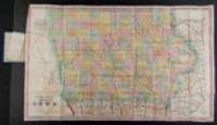
G. W. Colton's Township Map of the State of Iowa
por IOWA - COLTON, George W. (1827-1901)
- Condição
- Usado
- Published
- 1869
- Quantidade Disponível
- 1
- Livreiro
-
New York, New York, USA
- Preço do item
-
€ 473,00
Mostrar detalhes
Descrição:
New York: G.W. & C.B. Colton, 1869. Folding pocket map, full period hand-colouring, ornamental border. Census table at lower right. Folds into publisher's blindstamped cloth covers, title stamped in gilt on the upper cover, Colton ad on the front pastedown. Colton pocket map of Iowa.
Iowa experienced explosive growth during the 1860s, largely as a result of the… Ler mais sobre este item Preço do item
€ 473,00

Mais fotos
Map of the State of New York Compiled from the Latest Authorities
por [MITCHELL, S. Augustus]
- Condição
- Usado
- Published
- 1834
- Quantidade Disponível
- 1
- Livreiro
-
New York, New York, USA
- Preço do item
-
€ 425,70
Mostrar detalhes
Descrição:
Philadelphia: S. Augustus Mitchell, 1834. Full period color, 17 x 20 1/2 inches, folding into gilt-stamped brown leather covers. Statistical table laid down on inside front cover. Five insets (see below). Minor repairs. This is the second pocket map edition of D. H. Vance's map of New York State with the imprint of S. Augustus Mitchell. Mitchell had purchased… Ler mais sobre este item Preço do item
€ 425,70

Mais fotos
The Tourist's Map of the State of New York Compiled from the Latest Authorities
por WILLIAMS, William
- Condição
- Usado
- Published
- 1828
- Quantidade Disponível
- 1
- Livreiro
-
New York, New York, USA
- Preço do item
-
€ 756,80
Mostrar detalhes
Descrição:
Utica: William Williams, 1828. Engraved by V. Balch & Stiles." Period outline color, (19 3/4 x 20 1/2 inches on a 19 3/4 x 28 1/4 inch sheet) with nine columns of text entitled "Stage, Canal and Steam-Boat Register" at right. Folding into gilt-stamped brown leather covers. Three columns of descriptive text entitled "Erie Canal." Fine condition. Second edition,… Ler mais sobre este item Preço do item
€ 756,80

Mais fotos
Map of the State of New York Compiled from the Latest Authorities
por [MITCHELL, S. Augustus]
- Condição
- Usado
- Published
- 1839
- Quantidade Disponível
- 1
- Livreiro
-
New York, New York, USA
- Preço do item
-
€ 283,80
Mostrar detalhes
Descrição:
Philadelphia: S. Augustus Mitchell, 1839. Full period color, (17 x 20 1/2 inches), folding into gilt-stamped brown leather covers. Statistical table laid down inside front cover. Minor repairs, a bit of staining. The fourth Mitchell edition of D.H. Vance's map of New York State. Extensive additions to New York's embryonic railroad system, both on the main and the inset… Ler mais sobre este item Preço do item
€ 283,80

Mais fotos
Map of the State of Virginia containing the counties, principal towns, railroads, rivers, canals & all other internal improvements
por [BUCHOLTZ, Lewis von]
- Condição
- Usado
- Published
- 1862
- Quantidade Disponível
- 1
- Livreiro
-
New York, New York, USA
- Preço do item
-
€ 6.149,00
Mostrar detalhes
Descrição:
Richmond: West & Johnson, 1862. Folding lithographed pocket map, ornamental border, inset view of Richmond. Sheet size: (27 1/2 x 37 inches). Folds into original dark blue and gilt card covers. Provenance: David B. Langston, 3d Georgia Regiment, Company K (pencil signature). Rare Confederate pocket map of Virginia, with provenance to an officer in the 3rd Georgia.
This… Ler mais sobre este item Preço do item
€ 6.149,00

Mais fotos
Chapman's Sectional Map of the State of Iowa Compiled from the United States Surveys and other authentic Sources
por IOWA - CHAPMAN, Silas (1813-1899)
- Condição
- Usado
- Published
- 1857
- Quantidade Disponível
- 1
- Livreiro
-
New York, New York, USA
- Preço do item
-
€ 567,60
Mostrar detalhes
Descrição:
Milwaukee: Dyer & Pasmore, 1857. Folding pocket map, full period hand-colouring. Folds into publisher's blindstamped green cloth covers, title stamped in gilt on upper cover, publisher's ad on the front pastedown. Lovely copy of Chapman's Iowa.
This large, early map of Iowa shows each county divided into ranges, with the state's principal towns and numerous rivers identified, as… Ler mais sobre este item Preço do item
€ 567,60

Mais fotos
Map of the United States constructed from the latest authorities
por WILLIAMS, C. S.
- Condição
- Usado
- Published
- 1833
- Quantidade Disponível
- 1
- Livreiro
-
New York, New York, USA
- Preço do item
-
€ 1.419,00
Mostrar detalhes
Descrição:
New York: C.S. Williams, 1833. Engraved folding pocket map, period hand-colouring in outline, statistical table in lower left corner. Folding index sheet. Folds into publisher's cloth-backed paper boards, titled on upper cover "Williams' Travellers' Directory...". (Boards worn, some repaired separations at folds). Scarce map depicting the U.S. as far west as the Rockies.
This small "Travellers Directory" (as… Ler mais sobre este item Preço do item
€ 1.419,00

Mais fotos
Plan of Boston comprising a part of Charlestown and Cambridge
por SMITH, George G. (1795-1878)
- Condição
- Usado
- Published
- 1855
- Quantidade Disponível
- 1
- Livreiro
-
New York, New York, USA
- Preço do item
-
€ 2.601,50
Mostrar detalhes
Descrição:
Boston: George G. Smith ... Also by Ide and Dutton, 1855. Engraved folding pocket map, period hand-colouring in outline. Inset maps of South Boston and East Boston. Street index along the left margin. Folds into publisher's blindstamped cloth covers, title stamped in gilt on the upper cover, Ide & Dutton advertisement on the front pastedown. A noted mid-19th century… Ler mais sobre este item Preço do item
€ 2.601,50

Mais fotos
A Map of Worcester Shire Town of the County of Worcester
por STEBBINS, Heman S. (1791-1838)
- Condição
- Usado
- Published
- 1833
- Quantidade Disponível
- 1
- Livreiro
-
New York, New York, USA
- Preço do item
-
€ 2.838,00
Mostrar detalhes
Descrição:
[Worcester]: Published by C. Harris, 1833. Lithographed folding map, printed on two sheets joined, period hand-colouring in outline. Inset map of the "Village of Worcester." Ten vignette views of buildings, including churches, schools, the "Antiquarian Hall" (i.e. American Antiquarian Society), town hall, the "Lunatic Hospital" and "House of Corrections." The scarcest and most decorative map of Worcester published in… Ler mais sobre este item Preço do item
€ 2.838,00
Mais fotos
A Township Map of the State of Iowa Compiled from the United States Surveys, official information and personal reconnaissance, showing the streams, roads, towns, post offices, county seats, works of internal improvement, &c., &c
por IOWA - HENN, WILLIAMS & Co. and R. BARNES (publishers)
- Condição
- Usado
- Published
- 1855
- Quantidade Disponível
- 1
- Livreiro
-
New York, New York, USA
- Preço do item
-
€ 567,60
Mostrar detalhes
Descrição:
Fairfield, Iowa and Philadelphia: Henn, Williams & Co. and R. Barnes, 1855. Folding pocket map lithographed by Friend & Aub of Philadelphia, full original period hand colouring. Folds into original blue cloth covers, blocked in blind, the upper cover with publisher and title in gilt. A fine copy of this attractive map of Iowa from the early years of… Ler mais sobre este item Preço do item
€ 567,60
![The Western Tourist and Emigrant's Guide through the States of Ohio, Michigan, Indiana, Illinois, and Missouri, Iowa and Wisconsin, and the Territories of Minesota [sic.], Missouri, and Nebraska ... Accompanied with a large and minute Map](https://d3525k1ryd2155.cloudfront.net/h/564/111/298111564.0.m.jpg)
Mais fotos
The Western Tourist and Emigrant's Guide through the States of Ohio, Michigan, Indiana, Illinois, and Missouri, Iowa and Wisconsin, and the Territories of Minesota [sic.], Missouri, and Nebraska ... Accompanied with a large and minute Map
por COLTON, J.H. (publisher) - John Calvin SMITH
- Condição
- Usado
- Published
- 1852
- Quantidade Disponível
- 1
- Livreiro
-
New York, New York, USA
- Preço do item
-
€ 662,20
Mostrar detalhes
Descrição:
New York: published by J.H. Colton, 1852. 89pp. plus 18pp. catalogue of maps, etc., published by Colton. Large folding map: Smith, J. Calvin: "Guide Through Ohio, Michigan, Indiana, Illinois, Missouri, Wisconsin & Iowa, Showing the Township lines of the United States Surveys, Location of Cities, Towns, Villages, Post Hamlets, Canals, Rail and Stage Roads." New York: J.H. Colton, 1852.… Ler mais sobre este item Preço do item
€ 662,20

Mais fotos
Topographical Map of New York and Vicinity Embracing Fifteen Cities and Above 1700 Square Miles
por DRIPPS, Matthew (publisher)
- Condição
- Usado
- Published
- 1870
- Quantidade Disponível
- 1
- Livreiro
-
New York, New York, USA
- Preço do item
-
€ 2.838,00
Mostrar detalhes
Descrição:
New York: M. Dripps, 1870. Hand-coloured lithographic folding map (sheet size: 28 x 28 inches), within a brown cloth wallet (5 1/4 x 3 1/4 inches), (splits at folds). Two insets: Map of Long Branch [NJ] and Vicinity; Navesink Park. 1p. publisher's price list tipped onto front pastedown. A fine example of this important map, published at a period… Ler mais sobre este item Preço do item
€ 2.838,00
