
Ver em tamanho grande.
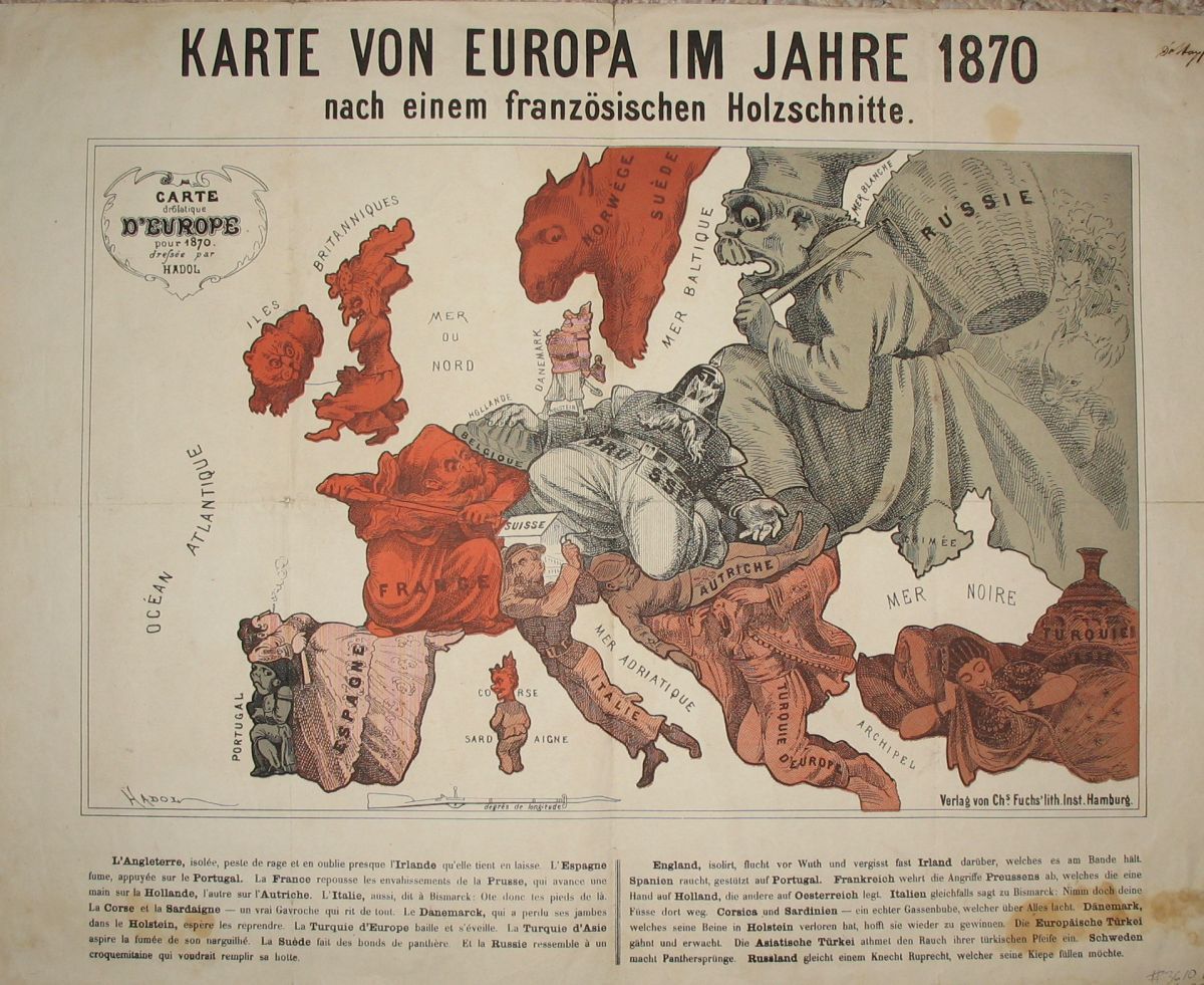
(Satirical political map of Franco-Prussian War): Karte von Europa im Jahre 1870 nach einem französischen Holzschnitte
por Hadol (Paul)
- Usado
- first
- Condição
- Veja a descrição
- Livreiro
-
Crozet, Virginia, United States
Formas de pagamento
Sobre este item
Hamburg: Fuchs, 1914. Very good, on thin paper, with original color, folds as issued (now flattened with some archival tape repair at folds on verso). Mild foxing most evident n lower margin. These maps, often ephemeral in nature, are now all increasingly scarce. Although the date on the map is 1870, it was published by Fuchs ("Verlag von Chs. Fuchs' lith. Inst. Hamburg" in lower right margin just outside neatline), and the text in the lower margin is in both German and French. The map image measures 24 x 38 cm. on a sheet 36 x 46 cm. There is a second title within the neatline: Carte drôlatique d'Europe pour 1870.. First Edition Thus.
Detalhes
- Livreiro
- The Prime Meridian: Antique Maps & Books
 (US)
(US)
- Nº do estoque do livreiro
- 3610
- Título
- (Satirical political map of Franco-Prussian War): Karte von Europa im Jahre 1870 nach einem französischen Holzschnitte
- Autor
- Hadol (Paul)
- Estado do livro
- Usado
- Edição
- First Edition Thus
- Editorial
- Fuchs
- Local de publicação
- Hamburg
- Data de publicação
- 1914
- Palavras-chave
- Serio-Comic Maps, Military History, Political Satire, Cartography , Europe
- Catálogos de livreiros
- D. Maps--General;
Termos da venda
The Prime Meridian: Antique Maps & Books
We accept cash, check, money order, American Express, Visa, Discover and Mastercard. Virginia sales tax will be added to instate purchases. Shipping charges are billed at cost, and will be added to the invoice. We usually include insurance with the postage, and as a result we do not routinely use media mail. If you wish the book sent via the latter route, it would be at your risk. For heavy items, there may be extra shipping charges. Any item maybe returned (postpaid and carefully packed by purchaser) within 7 days of receipt. We do not generally refund postal charges. Please notify us before sending a return. We do not share customer information with any outside sources; all details and addresses are confidential.
Sobre o Vendedor
The Prime Meridian: Antique Maps & Books
Membro de Biblio desde 2005
Crozet, Virginia
Sobre The Prime Meridian: Antique Maps & Books
The Prime Meridian: Antique Maps & Books is owned and operated by Joel & Deborah Kovarsky. We first opened in 1998, but have had a decades-old interest in old maps, books, and paper, stemming from a comparable long-standing interest in how knowledge is used. Our business is run via the internet. We do not run an open shop, however we do welcome visitors by appointment only. Before attempting a visit, please contact us. We are a specialty business, dealing in antiquarian maps and related books (atlases, history of cartography, selected reference books, etc.). Please feel free to contact us for specific inquiries.
Glossário
Alguns termos que podem ser usados ??nesta descrição incluem:
- First Edition
- In book collecting, the first edition is the earliest published form of a book. A book may have more than one first edition in...
Perguntas frequentes
Categorias deste livro
Also Recommended
-

-

-

-

-

Economize 10% em cada compra!
Junte-se ao Clube dos Bibliófilos e comece a economizar 10% em cada livro.
$29.95 / Ano