
Ver em tamanho grande.
MAP OF KENT - 1894
por J.H.F. Brabner
- Usado
- Muito Bom
- Brochura
- Condição
- Very Good
- Livreiro
-
South Kelsey, Lincolnshire, United Kingdom
Formas de pagamento
Sobre este item
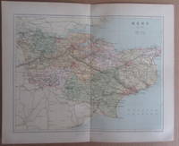
United Kingdom: William Mackenzie. This is the 1894 coloured maps of Kent taken from 'The comprehensive gazetteer of England and Wales' edited by J.H.F. Brabner, published in 1894. Each map measures 32 x 25 cms and has a centre fold . Very Good. Soft cover. 1894.
Avaliações
(Entrar ou Criar uma conta primeiro!)
Detalhes
- Livreiro
- Winghale Books
 (GB)
(GB)
- Nº do estoque do livreiro
- 089485
- Título
- MAP OF KENT - 1894
- Autor
- J.H.F. Brabner
- Formato/Encadernação
- Soft cover
- Estado do livro
- Usado - Very Good
- Quantidade Disponível
- 1
- Encadernação
- Brochura
- Editorial
- William Mackenzie
- Local de publicação
- United Kingdom
- Data de publicação
- 1894
Termos da venda
Winghale Books
30 day return guarantee, with full refund including original shipping costs for up to 30 days after delivery if an item arrives misdescribed or damaged.
Sobre o Vendedor
Winghale Books
Membro de Biblio desde 2013
South Kelsey, Lincolnshire
Sobre Winghale Books
Internet Only. UK Bookseller we have been selling academic history books for over 20 years and although our stock is still mainly history we now cover other academic subject areas.
