Ver em tamanho grande.

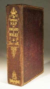
The Imperial Map of England and Wales
- Usado
- Muito Bom
- Brochura
- Condição
- Muito Bom
- Livreiro
-
Farningham, Kent, United Kingdom
Formas de pagamento
Sobre este item
London & Edinburgh: A Fullarton & Co The Imperial Map of England and Wales according to the Ordnance Survey, with the latest additions shewing clearly every feature of the country, Railways and their Stations, Roads, Canals, Rivers, Gentlemens Seats etc. on the scale of 4 miles to an inch by John Bartholomew. 19 linen backed sheets numbered 1-15 plus 16 A,B and C. together with a folded index sheet. Flat sheet size, 550x750mm, folded size 275x185mm. All the maps in first class condition with no distress to folds. The folds to the paper index sheet have at some time been rather crudely stregthened. The whole enclosed in the original leathered covered box with an envelope style lid.
Avaliações
(Entrar ou Criar uma conta primeiro!)
Detalhes
- Livreiro
- Wadard Books PBFA
 (GB)
(GB)
- Nº do estoque do livreiro
- 17573
- Título
- The Imperial Map of England and Wales
- Formato/Encadernação
- Soft cover
- Estado do livro
- Usado - Muito Bom
- Quantidade Disponível
- 1
- Encadernação
- Brochura
- Editorial
- A Fullarton & Co
- Local de publicação
- London & Edinburgh
- Dimensão
- 290x200mm
- Palavras-chave
- Fullartons Cased Set.
Termos da venda
Wadard Books PBFA
30 day return guarantee, with full refund including original shipping costs for up to 30 days after delivery if an item arrives misdescribed or damaged.
Sobre o Vendedor
Wadard Books PBFA
Membro de Biblio desde 2014
Farningham, Kent
Sobre Wadard Books PBFA
The shop of Wadard Books is located in a listed 17th century timber framed building in the historic Kentish village of Farningham. The business is named after Wadard, one of Farningham's Domesday landlords, a henchman of Bishop Odo and featured on the Bayeaux tapestry.