Descrição:
[Boston: B. & J. Loring, 1801. Copper-engraved map, with original outline colour, folded and mounted on linen. Publisher's paper label to verso, in good condition apart from some slight browning. Modern cloth chemise, within a morocco-backed cloth slipcase. A very rare and highly important early map of Massachusetts. The revised and much improved first "official" edition of the most important early map of Massachusetts. In three key ways, this edition is a great improvement over Osgood Carleton's 1798 original which was rejected for official sanction by the government of the Commonwealth. Firstly, the coastline and coastal islands have been more correctly rendered, largely due to the incorporation of information from the charts of Joseph Des Barres. Secondly, roads and streams that had been left incomplete in the earlier map were extended. Thirdly, some of the clutter of the 1798 map, engraved by Carleton's partner, John Norman, was removed, and the map is more attractive and informative, with a…
Ler mais [COOK] Newton’s new & improved terrestrial pocket globe 1817 por NEWTON FAMILY
por NEWTON FAMILY
![[COOK] Newton�s new & improved terrestrial pocket globe 1817 por NEWTON FAMILY](https://d3525k1ryd2155.cloudfront.net/h/926/764/1547764926.0.m.jpg)
[COOK] Newton’s new & improved terrestrial pocket globe 1817
por NEWTON FAMILY
- Usado
London : John Newton, 1st January 1817. Terrestrial pocket globe, 3 inches in diameter, engraved gores with original hand colour over papier-mâché and plaster sphere, the surface in fine order with a recent wax applied for protection, two metal pins resting the globe in the original publisher's shagreen case, titled Newton's improved pocket celestial globe, with engraved diagrams of the constellations, the lips coloured red, original metal hinge and two hook and eye clasps. A fine example of a rare pocket globe, sitting perfectly within its case. A rare and attractive miniature pocket globe showing Cook's third voyage. John Newton (1759-1844) was the founder of a firm of globe makers in London, established in the 1780s and continuing on, with the involvement of Newton's sons, throughout the nineteenth century. This small terrestrial globe in its original case shows the track of Cook's third voyage of 1776-80, with its return to England under the commands of Clerke and Gore. New Holland is shown separated from Van Diemen's Land, Port Jackson and Botany Bay are marked, and interestingly 'French Discoveries' are captioned along the South Australian coastline, a reference to the Baudin expedition. An analemma is drawn over the Pacific Ocean and the 'Antipodes of London' are marked south of New Zealand. References: Dekker, Elly, et al. Globes at Greenwich: A Catalogue of the Globes and Armillary Spheres in the National Maritime Museum, Greenwich. London: Oxford University Press and the National Maritime Museum, 1999, pp. 424 - 425 (GLBO58) Sumira, Sylvia. The art and history of globes. London : The British Library, 2014, p. 189 (the 1831 edition, illustrated).
-
Livreiro
Independent bookstores
 (AU)
(AU)
- Estado do livro Usado
- Quantidade Disponível 1

Mais fotos
Map of Massachusetts proper compiled from Actual Surveys made by Order of the General Court, and under the inspection of agents of their appointment
por CARLETON, Osgood (fl.1792-1806)
- Usado
- Condição
- Usado
- Encadernação
- Unknown
- Quantidade Disponível
- 1
- Livreiro
-
New York, New York, United States
- Preço do item
-
€ 17.055,00
Mostrar detalhes
Preço do item
€ 17.055,00

Mais fotos
MAP OF PHILADELPHIA, CAMDEN AND VICINITY Compiled from City Plans & Personal Surveys
por Smith, Elvino V.
- Usado
- Capa dura
- Condição
- Usado - Good+
- Encadernação
- Hardcover
- Quantidade Disponível
- 1
- Livreiro
-
Fairfield, New Jersey, United States
- Preço do item
-
€ 284,25
Mostrar detalhes
Descrição:
Philadelphia: Elvino V. Smith. Good+. 1912. Hardcover. A very large folding map (56" x 43") mounted in a light blue, lightly faded, hardcover cloth folder with gilt lettering on front. Map in nice condition except for a few tears along the folds. Folder has paper tears along interior hinges. Condition--Folder: G+, Map: VG. Pennsylvania ; Fold out Map; Thin 12mo 7" - 7½" tall .
Preço do item
€ 284,25

Mais fotos
Historia de Gentibus septentrionalibus, earumqve diversis statibus, conditionibus, moribus, ritibus, superstitionibus, disciplinis, excercitiis, regimine, victu, belleis, structuris, instrumentis, ac mineris metallicis, & rebus mirabilibus, necnon uni... - [THE LARGE COMMENTARY TO "CARTA MARINA"]
por MAGNUS, OLAUS.
- Usado
- Capa dura
- first
- Condição
- Usado
- Encadernação
- Hardcover
- Quantidade Disponível
- 1
- Livreiro
-
Copenhagen, Denmark
- Preço do item
-
€ 15.421,50
Mostrar detalhes
Descrição:
1555. Romae, (Colophon: Apud Ioannem Mariam de Viottis Parmensem, in aedibus Birgitttae), 1555. Folio. Bound to style in later (around 1950) full vellum with 4 raised bands to spine. Endpapers renewed. Old owners name on foot of titlepage. 42 unnumb. leaves + 815 pp. (p. 815 is the full page woodengraved printers device, verso blank). With 472 fine woodcuts in the text, the greatest part measuring 59x93 mm, a few half-page and some 1/3-page, among these the full-page map over Scandinavia (the smaller sized "Carta Marina"). Only few scattered brownspots, probably lightly washed by the rebinding. From ab. p. 500 the upper margins have some faint dampspots, which on ab. 25 leaves has left some small loss of paper, and on a few places the loss of a letter in the caption title, but everywhere professionally repaired with paperpulp where needed. First edition of Magnus' great work, which constitutes the first larger geographical-ethnographical description of Scandinavia and one of the most important…
Ler mais Preço do item
€ 15.421,50
Mais fotos
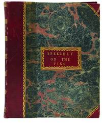
Treatise on the Culture of the Vine
por Speechly, William
- Usado
- first
- Condição
- Usado
- Encadernação
- Unknown
- Quantidade Disponível
- 1
- Livreiro
-
Melbourne, Victoria, Australia
- Preço do item
-
€ 3.411,18
Mostrar detalhes
Descrição:
York: G Peacock, 1790. Second-hand hardcover. Speechly, William. A Treatise on the Culture of the Vine. G Peacock for the author: York, 1790. 4to half bnd red morocco, marbled bds, xvi,[4],224pp. SPEECHLY, William (1735-1819) A Treatise on the Culture of the Vine: exhibiting new and advantageous methods of propagating, cultivating, and training that plant, so as to render it abundantly fruitful. Together with new hints on the formation of vineyards in England. York: printed for the author by G Peacock; and sold by G Nicol, bookseller to his Majesty, Pall-Mall; J Debrett and J Stockdale, Piccadilly; and E Jeffery, near Carleton-Place, London, 1790. First edition. Quarto (275x220mm) half bound, red straight grained morocco, marbled boards and end-papers, label to front board, spine and label lettered, ruled & decorated in gilt, xvi, [4 subscribers list],224pp; five steel engraved plates, three folding; four of the plates are signed by James Basire, engraver. Three plates are after originals by…
Ler mais Preço do item
€ 3.411,18

Mais fotos
Atlas of New York and vicinity : from actual surveys
por BEERS, F.W.
- Usado
- Perto de Excelente
- Capa dura
- Condição
- Usado - Perto de Excelente
- Encadernação
- Hardcover
- Quantidade Disponível
- 1
- Livreiro
-
COLUMBIA, Missouri, United States
- Preço do item
-
€ 900,12
Mostrar detalhes
Descrição:
1867 HUGE ATLAS New York City Brooklyn Yonkers Color City MAPS FW BeersA rare 19th-century atlas of New York! Collected by F.W. Beers, this enormous atlas contains numerous maps contains views of New York City, cities and towns, Burroughs, and neighborhoods, as well as illustrations of iconic locations and buildings. Notable maps included in this atlas include:
·
Peekskill
·
Beekmantown, Tarrytown, Irving
·
Putnam Valley and Philipstown
·
Cortland
·
Singsing
·
Yonkers
·
New York City
·
Brooklyn
Item number: #18366
Price: $950
BEERS, F.W.
Atlas of New York and vicinity : from actual surveys
New York : F.W. Beers, A.D. Ellis, and G.G. Soule, 1867.
Details:
·
Collation: Complete with all pages
o 35 maps
·
Provenance: Handwritten – John Bailey
·
Language: English
·
Binding: Leather; secure
·
Size: ~17.75in X 14.75in (45cm x 37.5cm)
Our Guarantee:
Very Fast. Very Safe. Free Shipping Worldwide.… Ler mais
Preço do item
€ 900,12
Mais fotos
Map of Massachusetts proper compiled from Actual Surveys made by Order of the General Court, and under the inspection of agents of their appointment
por CARLETON, Osgood (fl.1792-1806)
- Usado
- Condição
- Usado
- Encadernação
- Unknown
- Quantidade Disponível
- 1
- Livreiro
-
New York, New York, United States
- Preço do item
-
€ 17.055,00
Mostrar detalhes
Descrição:
[Boston: B. & J. Loring, 1801. Copper-engraved map, with original outline colour, folded and mounted on linen. Publisher's paper label to verso, in good condition apart from some slight browning. Modern cloth chemise, within a morocco-backed cloth slipcase. A very rare and highly important early map of Massachusetts. The revised and much improved first "official" edition of the most important early map of Massachusetts. In three key ways, this edition is a great improvement over Osgood Carleton's 1798 original which was rejected for official sanction by the government of the Commonwealth. Firstly, the coastline and coastal islands have been more correctly rendered, largely due to the incorporation of information from the charts of Joseph Des Barres. Secondly, roads and streams that had been left incomplete in the earlier map were extended. Thirdly, some of the clutter of the 1798 map, engraved by Carleton's partner, John Norman, was removed, and the map is more attractive and informative, with a…
Ler mais Preço do item
€ 17.055,00

Zemepis Sveta - Monsunova Asie
por De La Blache, P. Vidal; Gallois, L
- Usado
- Capa dura
- Condição
- Usado - Very Good Condition
- Condição de sobrecapa
- No Dust Jacket
- Encadernação
- Hardcover
- Quantidade Disponível
- 1
- Livreiro
-
Oak Point, Texas, United States
- Preço do item
-
€ 56,85
Mostrar detalhes
Descrição:
Aventinum, Prague, Czechoslovakia, 1931. Hardcover. Very Good Condition/No Dust Jacket. Text entirely in Czech. Geography book on Asia with numerous photographs and maps. 1930 edition also available. Size: 4mo - over 9 3/4" - 12" tall. 400 pp. Pages are yellowed, but are tight and clean. Moderate shelfwear along the spine. Corners are lightly bumped. Quantity Available: 1. Shipped Weight: 3-5 pounds. Category: Travel & Places; Non-English Language::Czech; Pictures of this item not already displayed here available upon request. Inventory No: 001228. . Additional shipping charges may apply.
Preço do item
€ 56,85

Mais fotos
Hertfordshire maps: a descriptive catalogue of the maps of the county 1579 - 1900
por Fordham, Herbert George
- Usado
- Bom
- Brochura
- Assinado
- Condição
- Usado - Bom
- Encadernação
- Paperback
- Quantidade Disponível
- 1
- Livreiro
-
Shipston on Stour, Warwickshire, United Kingdom
- Preço do item
-
€ 149,75
Mostrar detalhes
Descrição:
Hertford: Stephen Austin & Sons Ltd, 1907 Book. Good. Soft cover. Numbered 12 of 50 copies. xii, 182 pages + plates. Loosely inserted is an autograph letter signed by the author to his brother Ernest presenting this copy of the book - he talks about defectively printed plates and that he will send replacements however difficult to see what the problems were with the plates unless the brother has replaced them. In the original paper covers, front cover detached and held on loosely by three strips of tape. Covers torn at the edges. A heavy volume, extra postage will be required to send it outside the UK.
Preço do item
€ 149,75
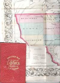
COLTON'S TOWNSHIP MAP OF THE STATE OF IOWA: Compiled from the United Statees Surveys & other Authentic Sources.; Drawn by George W. Colton. Engraved by J.M. Atwood
por Iowa
- Usado
- Bom
- Condição
- Usado - Bom
- Edição
- 1855 edition
- Encadernação
- Unknown
- Quantidade Disponível
- 1
- Livreiro
-
Roosevelt, New Jersey, United States
- Preço do item
-
€ 284,25
Mostrar detalhes
Descrição:
New York: J.H. Colton & Co, 1855. 1855 edition. Original Cloth. Good. Full-color engraved map, colored by hand, scrollwork border on all sides, opens to 25" x 29"; repairable separations at the intersections of several folds. Folds into red cloth case with embossed all-over design on both covers, gilt lettering on front. 5.5" x 3.75" [OCLC locates three holdings of this edition: Grinnell Col, U Iowa, Stanford U. Decker 23:225--1870 edition.].
Preço do item
€ 284,25
Mais fotos
Historia de Gentibus septentrionalibus, earumqve diversis statibus, conditionibus, moribus, ritibus, superstitionibus, disciplinis, excercitiis, regimine, victu, belleis, structuris, instrumentis, ac mineris metallicis, & rebus mirabilibus, necnon uni... - [THE LARGE COMMENTARY TO "CARTA MARINA"]
por MAGNUS, OLAUS.
- Usado
- Capa dura
- first
- Condição
- Usado
- Encadernação
- Hardcover
- Quantidade Disponível
- 1
- Livreiro
-
Copenhagen, Denmark
- Preço do item
-
€ 15.421,50
Mostrar detalhes
Descrição:
1555. Romae, (Colophon: Apud Ioannem Mariam de Viottis Parmensem, in aedibus Birgitttae), 1555. Folio. Bound to style in later (around 1950) full vellum with 4 raised bands to spine. Endpapers renewed. Old owners name on foot of titlepage. 42 unnumb. leaves + 815 pp. (p. 815 is the full page woodengraved printers device, verso blank). With 472 fine woodcuts in the text, the greatest part measuring 59x93 mm, a few half-page and some 1/3-page, among these the full-page map over Scandinavia (the smaller sized "Carta Marina"). Only few scattered brownspots, probably lightly washed by the rebinding. From ab. p. 500 the upper margins have some faint dampspots, which on ab. 25 leaves has left some small loss of paper, and on a few places the loss of a letter in the caption title, but everywhere professionally repaired with paperpulp where needed. First edition of Magnus' great work, which constitutes the first larger geographical-ethnographical description of Scandinavia and one of the most important…
Ler mais Preço do item
€ 15.421,50

Mais fotos
The Sky and the Forest
por Forester, C.S
- Usado
- Muito Bom
- Capa dura
- first
- Condição
- Usado - Muito Bom
- Condição de sobrecapa
- Very Good
- Edição
- First Edition
- Encadernação
- Hardcover
- Quantidade Disponível
- 1
- Livreiro
-
Salem, Oregon, United States
- Preço do item
-
€ 33,06€ 16,53Economize € 17,44!
Mostrar detalhes
Descrição:
C.S. Forester: The Sky and the Forest. Little, Brown and Company, Boston. Stated First Edition First Printing Thus August, 1948. Cover price $2.75. Used. VG BOOK/VG UNCLIPPED DUST JACKET. A story of a central Africa. By C.S. Forester, author of the Admiral Hornblower series.
Preço do item
€ 33,06€ 16,53
Economize € 17,44
!

Mais fotos
Old Decorative Maps and Charts
por Humphreys, Arthur L
- Usado
- Muito Bom
- Capa dura
- first
- Condição
- Usado - Very Good
- Condição de sobrecapa
- No Jacket
- Edição
- First Edition
- Encadernação
- Hardcover
- Quantidade Disponível
- 1
- Livreiro
-
Sumner, Iowa, United States
- Preço do item
-
€ 42,64
Mostrar detalhes
Descrição:
London: London: Halton & Truscott Smith, LTD>. Limited Edition of 1500 copies of which this is number No. 906---Clean, no marks, pages pristine. 79 maps dated 1482-1776 from engravings in the MacPherson Collection. Top Edge Gilt--No DJ Covers rubbed and very slight lean to spine----interior in excellent condition. . Very Good. Hardcover. First Edition. 1926.
Preço do item
€ 42,64

Mais fotos
Plat Book: Pierce County, Wisconsin
por Rhame, A. E
- Usado
- Bom
- Brochura
- Condição
- Usado - Bom
- Encadernação
- Paperback
- Quantidade Disponível
- 1
- Livreiro
-
Woodruff, Wisconsin, United States
- Preço do item
-
€ 44,21
Mostrar detalhes
Descrição:
1930. Soft Cover. Fine. Unpaginated. Tan colored book is in Fine condition, no sign of wear.
Preço do item
€ 44,21
![Alaska and Klondike Region; [With inset of Klondike Region on the Upper Yukon detail] [From an...](https://d3525k1ryd2155.cloudfront.net/h/062/537/1339537062.0.m.jpg)
Alaska and Klondike Region; [With inset of Klondike Region on the Upper Yukon detail] [From an atlas, "Gazetteer of Alaska and Yukon Region " pp. 105 and 106]
por Miller, J. Martin
- Usado
- Muito Bom
- Condição
- Usado - Muito Bom
- Edição
- Unknown
- Quantidade Disponível
- 1
- Livreiro
-
Sebastopol, California, United States
- Preço do item
-
€ 36,95
Mostrar detalhes
Descrição:
Chicago: J. Martin Miller, 1899. Unknown. Map. Very Good. [Map copyright 1899, printing date of Atlas later] [19.875x15.125in]; Colored map of Alaska with steamer routes from Portland and Seattle, insets of the Klondike Region on the Upper Yukon and Western portion of Aleutian Islands; On verso index of places and names with two large black and white images; Age toning to all edges, water stain marks on bottom, slight printing offset of colors, small chips and closed tears to lower edge;.
Preço do item
€ 36,95

Last Tales
por Dinesen, Isak
- Usado
- Muito Bom
- Capa dura
- first
- Condição
- Usado - Muito Bom
- Condição de sobrecapa
- Good+
- Edição
- First Edition
- Encadernação
- Hardcover
- Quantidade Disponível
- 1
- Livreiro
-
Salem, Oregon, United States
- Preço do item
-
€ 113,70€ 56,85Economize € 60,00!
Mostrar detalhes
Descrição:
Dinesen, Isak: Last Tales, A Collection of Twelve New Tales of Compelling Beauty 1957, Random House. First Edition. Stated First Printing Thus. Used. Very Good/Good+ original red dust jacket, price-clipped. Jacket states 11/57 on front flap. 5 3/4 X
Preço do item
€ 113,70€ 56,85
Economize € 60,00
!
Zemepis Sveta - Monsunova Asie
por De La Blache, P. Vidal; Gallois, L
- Usado
- Capa dura
- Condição
- Usado - Very Good Condition
- Condição de sobrecapa
- No Dust Jacket
- Encadernação
- Hardcover
- Quantidade Disponível
- 1
- Livreiro
-
Oak Point, Texas, United States
- Preço do item
-
€ 56,85
Mostrar detalhes
Descrição:
Aventinum, Prague, Czechoslovakia, 1931. Hardcover. Very Good Condition/No Dust Jacket. Text entirely in Czech. Geography book on Asia with numerous photographs and maps. 1930 edition also available. Size: 4mo - over 9 3/4" - 12" tall. 400 pp. Pages are yellowed, but are tight and clean. Moderate shelfwear along the spine. Corners are lightly bumped. Quantity Available: 1. Shipped Weight: 3-5 pounds. Category: Travel & Places; Non-English Language::Czech; Pictures of this item not already displayed here available upon request. Inventory No: 001228. . Additional shipping charges may apply.
Preço do item
€ 56,85

Zemepis Sveta - Monsunova Asie
por De La Blache, P. Vidal; Gallois, L
- Usado
- Capa dura
- Condição
- Usado - Very Good Condition
- Condição de sobrecapa
- No Dust Jacket
- Encadernação
- Hardcover
- Quantidade Disponível
- 1
- Livreiro
-
Oak Point, Texas, United States
- Preço do item
-
€ 56,85
Mostrar detalhes
Descrição:
Aventinum, Prague, Czechoslovakia, 1930. Hardcover. Very Good Condition/No Dust Jacket. Text entirely in Czech. Geography book on Asia with numerous photographs and maps. 1931 edition also available. Size: 4mo - over 9 3/4" - 12" tall. 400 pp. Pages are yellowed, but are tight and clean. Moderate shelfwear along the spine. Corners are lightly bumped. Quantity Available: 1. Shipped Weight: 3-5 pounds. Category: Travel & Places; Non-English Language::Czech; Pictures of this item not already displayed here available upon request. Inventory No: 001227. . Additional shipping charges may apply.
Preço do item
€ 56,85

The Adventure of Wrangel Island
por Vilhjalmur Stefansson
- Usado
- Bom
- Capa dura
- first
- Condição
- Usado - Bom
- Condição de sobrecapa
- No DJ Included
- Edição
- First Edition
- Encadernação
- Hardcover
- Quantidade Disponível
- 1
- Livreiro
-
Salem, Oregon, United States
- Preço do item
-
€ 118,33€ 59,17Economize € 62,44!
Mostrar detalhes
Descrição:
The Adventure of Wrangel Island, Alaska (1925 Macmillan 1st Edition) HISTORY OF ALASKA. EXLIB. Good Condition/ No DJ included. Fold-out map affixed to binding at the back of the book has never been opened. The story of the (unsuccessful) attempted colonization of Wrangel Island Alaska. 413 pages plus appendix, Index. Titling is still bright. A clean, solid copy. Scarce.
Preço do item
€ 118,33€ 59,17
Economize € 62,44
!

Seven Pillars Of Wisdom, A Triumph
por Lawrence, T.E
- Usado
- Bom
- Capa dura
- first
- Condição
- Usado - Bom
- Condição de sobrecapa
- No DJ Included
- Edição
- First American Edition
- Encadernação
- Hardcover
- Quantidade Disponível
- 1
- Livreiro
-
Salem, Oregon, United States
- Preço do item
-
€ 118,39€ 59,20Economize € 62,47!
Mostrar detalhes
Descrição:
T.E. Lawrence. SEVEN PILLARS OF WISDOM, A TRIUMPH. AUTOBIOGRAPHY. Privately Printed, 1926. First Published for general circulation 1935. First American Edition. States MCMXXXVI on the title page. Doubleday, Doran & Company, Inc. Garden City, NY. GOOD CONDITION/ NO DUST JACKET IS INCLUDED. 672 pages, indexed. Beige buckram boards. Spine has darkened a bit. 6 7/8 X 9 ½.
Preço do item
€ 118,39€ 59,20
Economize € 62,47
!

North America from the Best Authorities, Russell, ca.1800
por Russell
- Usado
- Condição
- Usado
- Quantidade Disponível
- 1
- Livreiro
-
Plymouth, Devon, United Kingdom
- Preço do item
-
€ 23,96
Mostrar detalhes
Descrição:
Russell, J. : A General Map of North America from the Best Authorities. Nd but ca.1800. From "A New Geographical, Historical and Commercial Grammar and Present State of Several Kingdoms of the World." Copper engraving. Size approx 200 x 230mm. Two neat folds. Some age colouring to edges, otherwise very clean and bright.
Preço do item
€ 23,96
