Descrição:
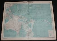
The Times, London, 1920. First Edition. Softcover. Very Good Condition/No Dust Jacket. Disbound single sheet with vertical centre fold from the 1920 "The Times Survey Atlas of the World". Map is in colour and sheet is suitable for framing. Land is coloured grey and sea is shades of blue according to depth. Map contains major currents/streams and directions are indicated by small arrows. Key shipping routes are marked. Mapped area includes; South Pacific Ocean, North and South Equatorial Currents, Equatorial Counter Current, Micronesia, Melanesia and Oceania, Australia, Tasmania, Hawaii, Papua New Guinea, Philippines, New Zealand, Fiji, Tonga, New Hebrides, Caroline Islands, East Indian Archipelago, Marquesas Islands, Chatham Island, Tuamotu or Low Archipelago, Lin Kin Islands, Magelhaes Archipelago, Soloman Islands, Bismark Archipelago, etc. Sheet has slightly darkened edges with occasional light foxing in the margins and edges of the mapped area. Sheet is otherwise clean and bright.…
Ler mais Resultados da Pesquisa: pacific ocean atlas plate
Você pesquisou por:
- Título: pacific ocean atlas plate
Resultados 1 - 1 de 1
Mais fotos
Map of South Pacific Ocean from the 1920 Times Atlas (Plate 102) including Australia, Hawaii, Papua New Guinea, Philippines, New Zealand, Fiji, Tonga, New Hebrides, Caroline Islands, East Indian Archipelago, Marquesas Islands, etc
por The Times and J. G. Bartholomew
- Usado
- Brochura
- first
- Condição
- Usado - Very Good Condition
- Edição
- First Edition
- Encadernação
- Paperback
- Quantidade Disponível
- 1
- Livreiro
-
Doncaster, Aberdeen, United Kingdom
- Preço do item
-
€ 28,75€ 17,37 frete para USA
Mostrar detalhes
Preço do item
€ 28,75
€ 17,37
frete para USA

Não encontrou o que estava procurando?
Tente adicionar esta pesquisa à sua lista de desejos. Milhões de livros são adicionados ao nosso site todos os dias e quando encontrarmos um que corresponda à sua pesquisa, enviaremos um e-mail. E o melhor de tudo, é grátis.
Adicionar à lista de desejos

Você é um leitor frequente ou colecionador de livros?
Junte-se ao Clube dos Bibliófilos e economize 10% em cada compra, todos os dias - até $20 de economia por pedido!

Responsabilidade social
Você sabia que desde 2004 a Biblio destina seus lucros à construção de 16 bibliotecas públicas em áreas rurais da América Latina?
